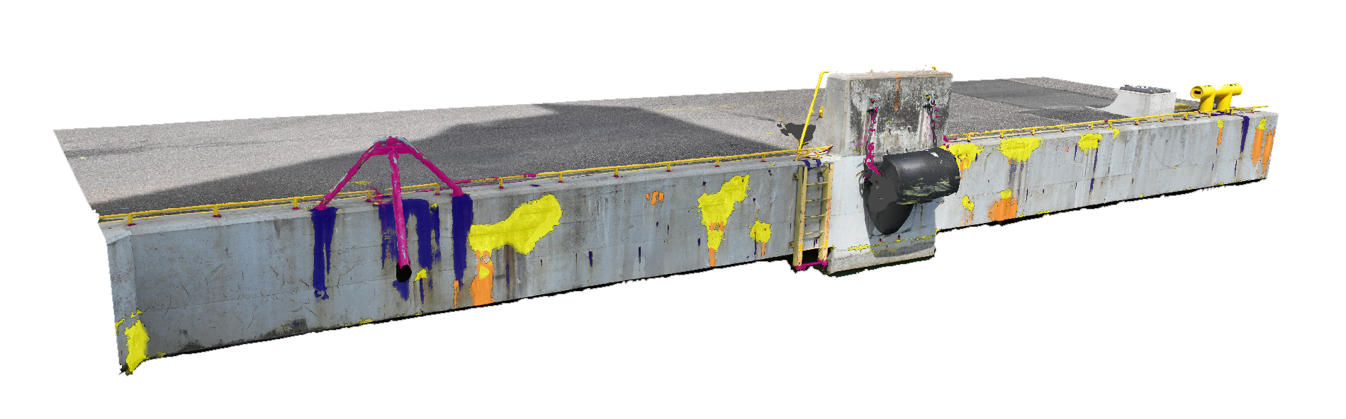
Mavisoft / Solutions / Infrascan

Your photogrammetry. Your engineers. Our platform.

Upload your drone surveys, handheld images, or 3D models. Infrascan runs AI defect detection and projects results onto your 3D model. Your engineers run inference, review, annotate, export.

Infrascan AI output — 3D quay wall mesh with defect overlay
What Infrascan does

From drone survey to a complete defect record.

Infrascan turns your existing survey data into a structured, queryable record of your asset's condition. No new capture workflows, no new hardware, no PDF that sits in a folder.

01 — Ingest

Works with the survey data you already produce.

Drone surveys, Metashape projects, GLB meshes, handheld image sets. Infrascan connects to what you already have. No new sensors, no new capture workflows, and no vendor lock-in on the hardware side.

02 — Detect

Full-asset coverage, not a sampled inspection.

AI runs across the entire dataset. Every crack, spall, corrosion instance, and deformation is found, classified, and assigned a severity. Nothing depends on an inspector's line of sight or available time on site.

03 — Export

Results in the formats your systems already use.

GeoJSON, shapefile, GeoTIFF, PDF inspection reports. Every output carries the defect coordinates, classification, and the model version that produced it. Ready for your asset register on the day the run completes.

Who it's for

Inspection reports describe your asset. Infrascan data lets you manage it.

A PDF inspection report tells you what was found. It cannot tell you where, relative to last year's survey, or in comparison across your portfolio. Infrascan produces records that live in systems, not documents that sit in folders.

The same dataset that serves an asset owner's maintenance planning also gives an engineering firm something more than a report to deliver to their client.

Asset owners

Track defect progression. Justify maintenance spend. Meet inspection requirements.

You commission inspections to stay ahead of maintenance costs and meet regulatory requirements. What most inspections deliver is a document. What you need is a dataset: where defects are on your asset, how they compare to the previous survey, and what needs attention before the next scheduled inspection.

Inspection and engineering firms

Deliver a GIS-ready defect dataset, not just a report.

Your clients are under pressure to move from periodic manual inspections to continuous, data-driven asset management. Delivering a GIS-ready defect dataset alongside your inspection report positions your firm as the partner that makes that shift possible, using the photogrammetry workflow you already run.

How it works

Survey upload to GIS-ready defect set in one run.

01

Upload your survey data

Drone images, Metashape projects, GLB meshes, or handheld image sets. Self-serve upload or managed delivery.

Drone · Metashape · GLB
02

AI detects every defect

The model runs across the full dataset. Cracks, spalls, corrosion, and deformation are found, classified, and assigned a severity.

Cracks · Spalls · Corrosion
03

Defects mapped to your model

Every defect is placed at its real-world position on your 3D asset. Coordinates are site-specific and CRS-explicit.

Real-world coords · Per-site CRS
04

Export for your workflow

GeoJSON, shapefile, GeoTIFF, or PDF inspection reports. Results feed directly into your asset management system.

GeoJSON · Shapefile · PDF
FAQ

Frequently asked questions.

The questions we hear most from operations leaders, technical evaluators, and procurement teams.

Metashape projects, GLB meshes, drone image sets, and raw image collections. If you have Metashape, Pix4D, ODM, or ContextCapture already deployed, your existing output is the input.

Yes. Upload, run inference, review detections, annotate, and export — the full loop without Mavisoft in the workflow. Managed delivery is available for teams who prefer to hand the pipeline off.

Each detection made in 2D image space is back-projected onto the 3D mesh using the original camera positions and a frustum ray-casting step. Every defect sits at a real-world coordinate on the asset's surface.

Yes. Every finding references the model version, workflow version, and site CRS that produced it. Evidence packages include frames, overlays, and geo context.

Typically a single asset or defined structure section. Your team uploads an existing drone survey, Infrascan runs inference, and you walk away with a structured defect record and a working review workflow — not a proof of concept.

Use Infrascan for your next survey.

Pilots are short, fixed-scope, and structured to recover implementation cost before any platform license commitment. Email or use the form.

Book a demo